23 January 2022
Using modern technology to unearth a medieval town
New technologies have allowed researchers to retrace Newtown in Co. Kilkenny without having to take a spade to the site. This article by Daniel O’Mahony, Teagasc Walsh Scholar & Jesko Zimmermann, Teagasc Cartographer first appeared on RTÉ Brainstorm recently
Newtown – medieval market town
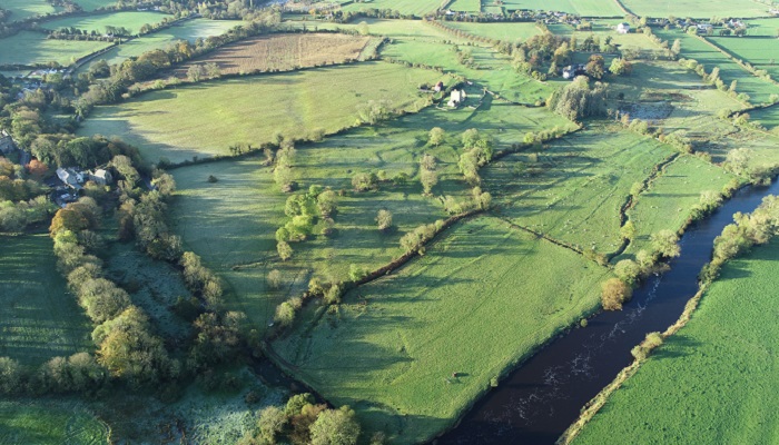
Little trace of the medieval market town of Newtown is left to the naked eye. Nowadays, only scattered ruins located within the green fields beside Jerpoint Abbey, Co. Kilkenny, provide a hint of what once has been. First incorporated as a borough in the early 13th century, the settlement has been abandoned since at least the early 18th century. While still noted in the historic Ordnance Survey Ireland 6 inch maps of the country, published 1842 (see image, the particular area was surveyed in 1836), the area of the former town is now completely under agriculture. According to local legend, and an entry on the OSI map, the local church also is the resting place of St. Nicholas.
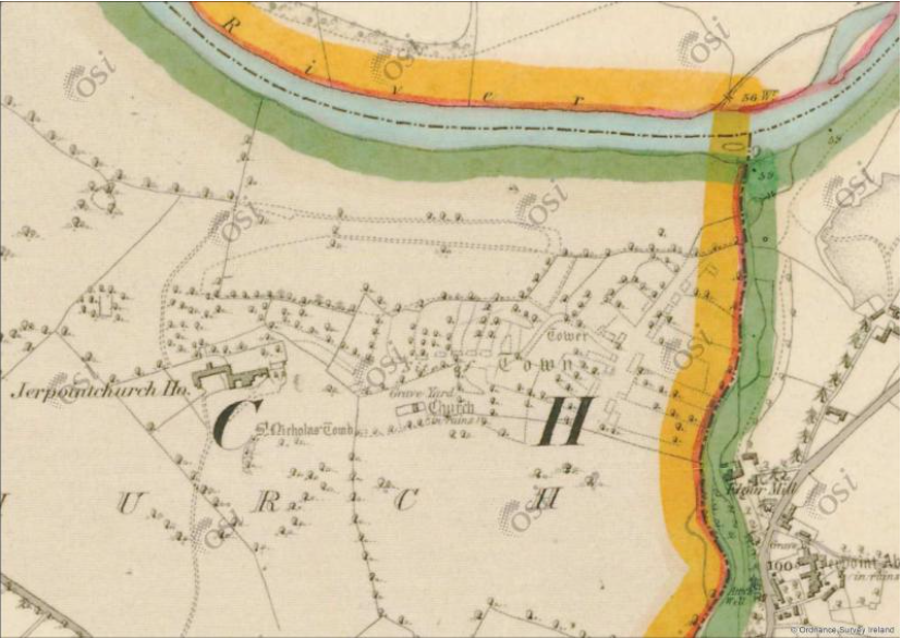
The town of Newtown; OSI Historic 6 inch Map; First Edition Colour
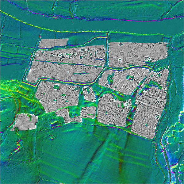
As part of his Teagasc Walsh Scholarship, Daniel O’Mahony, PhD student at the Department of Agrifood Business and Spatial Analysis, Teagasc, and the UCD School of Archaeology (supervised by Prof. Tadhg O’Keeffe, School of Archelogy, UCD & Dr. Stuart Green, Department of Agrifood Business and Spatial Analysis, Teagasc) is looking to advance our understanding of monuments on agricultural land using new technologies. Using two methods in particular, LIDAR and magnetic gradiometry, he was able to retrace the old structures of Newtown without having to take a spade to the site, unearthing long lost features such as ridge and furrow, two extended mill complexes, possible land drainage, domestic dwellings, and animal enclosures.
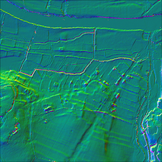
LIDAR image of the former medieval town of Newtown in Co Kilkenny
Light Detection and Ranging (LIDAR)
LIDAR, short for Light Detection and Ranging, also referred to as Laser Scanning or 3D scanning, is a remote sensing technology which uses laser beams to learn about the properties of faraway objects. One of the most common uses is the creation of high resolution terrain models. Due to its high precision nature, LIDAR can be used to both map and penetrate vegetation, providing unique insight into features otherwise hidden by the canopy. In archaeology, this allows surveyors and researchers to pick up the many traces left by human interaction with the landscape without the need for excavation, guiding them in their further investigations.
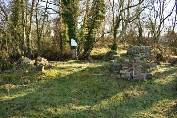
Photo above: Traces of Newtown in the landscape
In the image, we show LIDAR imagery taken from a helicopter-mounted sensor in 2007, showing the area of Newtown. While some of the traces are visible in the landscape (see photo above), LIDAR gives a much clearer image of how the village of Newtown may have looked. Looking at the image, we see the main road of Newtown, referred to in the records as the Long Street, framed by the remnants of dwellings. It is easy to imagine how the town may have looked, with the houses facing the road, while the long gardens stretch towards the river in the east, and into the fields in the west.
Magnetometer Survey
Magnetometer image of area where Newtown used to stand
Another technology applied is a magnetometer survey. A magnetometer is another non-invasive scanning method which can detect magnetic anomalies below ground. These can hint at buried structures, and other remnants of human settlement. The UCD School of Archaeology carried out magnetic gradiometry of the area in 2021 (using a SENSYS Magneto MX V3 magnetometer). While not as easy to interpret as the LIDAR imagery, the magnetometer does provide additional insights. In particular, it reveals what likely was a larger mill complex in the south east of the village, located right on the banks of the river. The main building is still visible in the LIDAR imagery as a square feature, as are some other traces of wider the milling area. The magnetometer imagery, however, reveals a clear anomaly further south, which indicates a much larger extent of area.
St. Nicholas’ Tomb
To the west of the town lie the ruins of the parish church. Already in ruins when the area was first mapped by the OSI, the old church ground is the site of a local legend: a decorative tomb in the graveyard supposedly being the final resting place of St. Nicholas, the patron saint of church. The origin of this myth may be traced to the mapping of the area for the 1st edition of the Ordnance Survey in 1839 as the surveyors of the day inserted a label, ‘St. Nicholas’ Tomb’, near the location of the church.
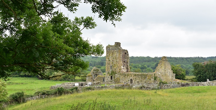
The ruins of the parish church
Acknowlegdements:
LIDAR survey: Commissioned by the Discovery Programme, and funded by the Heritage Council (2007)
Magnetometer survey: Commissioned by UCD School of Archaeology, and funded by the Heritage Council (2021).
OSI Historic 6 Inch, First Edition, coloured: Ordnance Survey Ireland
Photos: Daniel O’Mahony
This article first appeared on RTÉ Brainstorm. See Link to original article: https://www.rte.ie/brainstorm/2022/0118/1274278-newtown-kilkenny-ireland-medieval-town/
Read more on these and other fascinating maps produced by Teagasc at GIS Monthly Maps