Land Management
Approximately 75% of the pressures on water quality are from diffuse losses of Nitrogen (N), Phosphorus (P) and Sediment (Data from ASSAP). View ASSAP Interim Report. Soil type, rainfall and land management all contribute to these losses to waters at a field or farm scale.
How farmers manage the physical land area they farm can impact water quality. Many routine farming activities such as fertilizer/slurry application, pesticide application, reseeding, etc. can impacts on water quality. In most of these activities following good practice guidelines can mitigate against adverse effects on water quality and the environment.
Issues that arise with land management include:
- Diffuse nitrogen losses
- Phosphorous run-off and sediment losses
- Impacts of farm chemicals such as pesticides and sheep dip
- Critical Sourse Areas (CSA)
- Drainage
- Buffers
- Sheep dip and footbaths
Diffuse nitrogen losses
Nitrogen (N) loss typically occurs on soils that have high permeability. These are ‘light’ free draining soils and water can quickly permeate through these soils.
Where excess Nitrogen fertiliser is applied above crop requirement, this N is not utilised by the grass or tillage crop and is left in the soil. N does not bind tightly to soil like P and therefore when there is heavy rainfall, the water leaches N away to groundwater, streams and rivers. The natural biological processes in the soil increase the N available particularly in autumn. This requires careful management to minimise N losses at that time of the year.
Diffuse Phosphorus and Sediment losses
 Phosphorus (P) loss typically occurs on soils that have low permeability. These are poorly draining soils and get quickly saturated with rainfall. When there is heavy rainfall on these saturated soils this leads to the water staying on the surface of the soil. This in turns leads to overland flow of water, particularly on fields with slopes.
The overland flow of water across fields carries phospherorus in soluble form. It also washes off soil particles that have P attached to them. P binds tightly to soil particles. The soluble P and soil particles can then be washed into the drainage network and streams located in the farm and end up impacting on the quality of water in the streams.

Phosphorus losses
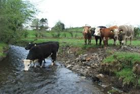
The implementation of appropriate buffer strips and prevention of livestock access to streams/rivers will help to reduce losses occurring.
Improved management of wet areas with high connectivity to the streams or rivers is also important. These Critical Source Areas (CSA’s) are more prone to nutrient and sediment loss during wet weather than the surrounding fields. Changes to land management in these areas can help reduce the impact on water quality.
Land drainage can increase sediment and phosphorus losses.
Surface and subsurface drains provides preferential flow paths for water. Poorly designed drainage systems and inappropriate use of fertilisers and pesticides can lead to an increase in losses of nutrients and chemicals to waters.
Drains can also add additional sediment to waters where poor land management – poaching or cattle access to drains and where drains are inappropriately managed and cleaned. For guidance on best practice when cleaning drains please click here.
Sediment & Drinking Points
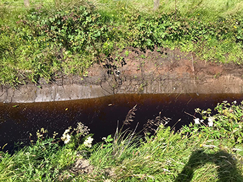
Sediment is the fine material associated with soils and can be both mineral and organic (e.g. peaty) in nature.
Sediment has a twofold effect on water quality. Excess sediment entering a watercourse can impact the river bed & loss of habitat. This will have an adverse effect on invertebrates and life cycles of a watercourse and result in a decrease in water quality.
Sediment carries other elements in association with it – phosphorous being the most significant. This phosphorous will become available in the water body and can cause algal blooms and plant proliferation.
Sediment can enter a water body as a result of a number of farm activities. These include drainage; drain maintenance, land reclamation, reseeding, out watering and poaching of land, watering points for cattle and inappropriate stream interactions.
Critical Source Areas – CSA’s
Critical Source Areas (CSA’s) are areas that are at highest risk of impacting a water body. These are often low-lying parts of farms where runoff accumulates in high concentration. Runoff from CSA’s carries sediment and nutrients to waterways.
Identification of these areas on a farm is necessary to reduce nutrient sediment and pesticide losses. It is important that appropriate farm management practices are applied on these areas.
The critical source areas (CSAs) often coincide with hydro-logically interconnected areas where overland and/or shallow subsurface water flows and transfers nutrients from the land to rivers and streams.
These CSAs vary across individual catchments and sometimes even within individual fields. As a result, effective measures to reduce nutrient losses will require differing levels of management that are appropriate for different areas of farmland within individual catchments.
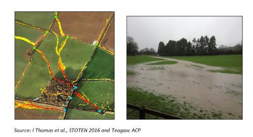
Image on the left is using Lidar technology to identify where water will flow across land in times of high rainfall and at what locations these flow paths intersect with drains or watercourses (blue dots). These flow path areas and intersection with drains, once identified can be targeted with specific measures to break the pathway of nutrient and sediment losses.
Image on the right is water flow paths across land during a high rainfall event.
Targeted mitigation actions that can be used to break the pathway include
- Riparian margins
- Buffer strips
- Sediments traps
- Hedgerows and tree planting
- Non application of nutrients at risky periods i.e. when soils are saturated
- Use of wetlands
Pollution Impact Potential (PIP) Maps
Pollution Impact Potential (PIP) maps have been developed by the EPA to help focus on the areas and sources that might be impacting water quality. . The maps help identify diffuse phosphorus (P) and diffuse nitrogen (N) losses.
The PIP maps are created using a combination of susceptibility maps which are then combined with nutrient loadings data provided by the Department of Agriculture, Food and the Marine (DAFM).
Looking at the phosphorus PIP map the darkest blue areas (PIP rank 1) show the farmland with the highest risk for diffuse P losses. These high risk areas often coincide with poorly drained land, meaning that in these areas P is more likely to flow overland to rivers and streams rather than being held in the soil. The lighter the colour the lower the potential for P loss. The maps are used as a tool to help identify where there are potential critical source areas (CSA’s) for P loss.
Similar maps are available for nitrate in surface water and groundwater. The areas of farmland with the highest risk of diffuse N loss are indicated by the darkest colours with lower risk farmland indicated with lighter colours.

Drainage
Drainage results in land carrying less water. This makes it more manageable for agricultural use and allows it to be more trafficable, carry more stock and have a longer growing season. However drainage can have an impact on water quality if not planned and designed properly.
Prior to carrying out any drainage works/land reclamation a cost/benefit analysis should be carried out on the economics of the project. In most cases, especially on Irish drystock farms, there is no financial benefit from drainage/land reclamation.
Consideration should also be given to the possible loss of habitats and biodiversity by new drainage works. Wetlands have the highest biodiversity value of any farm habitats. Furthermore it is likely that unimproved grasslands, grassland habitats and other farm habitats will receive the highest payments in future agri-environment schemes and are more valuable to retain on the farm than to drain or reclaim.
Drainage works are covered under the Environmental Impact Assessment Regulations. If the proposed area to be drained is above 15ha or will exceed this within a period of 5 years screening for the requirement for an Environmental Impact Assessment (or Natura Impact Assessment) by DAFM is required. EIA screening for drainage is required for works of any extent in NHAs, SAC’s and Natura sites. Screening for an EIA requirement is also required for reclamation of uncultivated or semi-natural areas for conversion to intensive agriculture up to a smaller area of 5ha. Draining of wetlands greater than 0.1ha requires planning consent from the Planning Authorities.

There is growing concern about inappropriate drainage works in upland areas leading to hydro morphology issues in catchments. This is because water is being carried too quickly in constructed drains or modified watercourses and having serious impacts downstream. These impacts include flash flooding, erosion, landslides and can have serious environmental and economic consequences.
Where it is decided to proceed with a new drainage project it is important that it is properly designed taking the site characteristics such as soils profiles, water tables, percolation status etc. into account before proceeding. Refer to the Teagasc Drainage Manual and consult with an adviser before proceeding. Ensure that environmental impact is minimised and that good practice in construction is observed.
In addition measures may need to be taken to prevent sediment entering watercourses as a result of drainage works. The same applies when drain maintenance or cleaning is carried out.
 When cleaning drains it is recommended that only one side of a drain is cleaned/excavated at a time with the alternate side being cleaned during a later subsequent drain cleaning operation. As much vegetation as possible should be retained on either side of the drain when cleaning as this will act as a buffer to nutrients such as phosphorous running off land. Drains should not be over-cleaned with only the lengths with impeded flow being addressed.
Removed spoil should be landspread well away from the drain. In order to avoid sediments entering a waterbody following drain cleaning (and a possible pollution incident) a length of uncleaned drain or blockage such as a straw bale should be kept at the lowest length of the drain to act as a sediment trap. This can be removed at a later date. Fish bearing or spawning streams should never be cleaned – please refer to Inland Fisheries Ireland if you have any concerns about drain cleaning.
Distinction should be made between drains and fish-bearing streams when it comes to maintenance.
Pesticides
Pesticides incorporate herbicides and biocidals and their use is regulated under the Sustainable Use Directive (2009). Pesticides by their nature are toxic and any possible access to waterbodies must be prevented.
Monitoring of drinking water in Ireland continues to detect exceedances above the standard for certain herbicides.
Drinking water standard = 0.1 microgram/L (1 drop in Olympic size swimming pool)
EPA update on exceedances in drinking water supplies:Recent data shows that there were 82 exceedances above the limit in 27 drinking water supplies. Although, the trends in the annual results are positive and clearly show a reduction in exccedances and supplies affected, the efforts by all stakeholders must continue.
| Number of exceedances | Number of supplies | |
|---|---|---|
| 2019 | 82 | 27 |
| 2018 | 85 | 34 |
| 2017 | 150 | 49 |
| 2016 | 137 | 44 |
It is essential for farmers to take great care and follow best practice procedures when using pesticides, in particular applying grassland herbicides. For tips on best practice advice click on video below.
Sheep dip and footbaths
Sheep dipping chemicals are insecticides used in the control of ecto-parasites of sheep. These are effective chemicals at control of these invertebrates but where they are allowed to access watercourses the chemicals will affect aquatic invertebrates in exactly the same manner.
Sheep dipping chemicals can have a lethal effect on these aquatic invertebrates and eliminate them over long stretches of watercourse where they are allowed entry. For best practice in the use of sheep dips see here.
When using a footbath precautions must be taken to prevent losses of foot bathing solution to water bodies including groundwater. Disposal of the foot bath solution should be done in accordance with best practice for the disposal of sheep dip.
Buffers
When spring arrives and it’s the start of the growing season farmers begin to apply nutrients to their lands. These nutrients can be in the form of chemical or organic fertilisers. Organic fertiliser includes soiled water, effluents, farmyard manure, slurry etc.
As well as abiding by the regulations governing good practice when deciding to apply these fertilisers the farmer must also know the relevant buffer zones.
A buffer zone is a no spread area which is used for the protection of water against nutrient, sediment or chemical losses and are usually sited alongside a water body or critical source area. Where managed correctly (e.g. grazed appropriately by livestock or harvesting of grass) they also act as a sink for mopping up nutrients before they reach a water body.
Buffer Zones for Fertiliser Spreading and use of Pesticides
| Chemical Fertiliser | Organinc Fertiliser | Farmyard Manure (FYM) Stored in a field** | Application of Pesticides and Chemicals*** | |
|---|---|---|---|---|
| Water Supply >100m³ or >500 people | 200m | 250m | ||
| Water Supply >10m³ or >50 people | 100m | 250m | ||
| Water Supply other | 25m | 50m | ||
| Lake shoreline | 20m | 20m | ||
| Exposed cavernous or karstified limestone features | 15m | 50m | ||
| Any surface watercourse where the slope towards watercourse is >10% | 10m | |||
| Any other surface waters * | 2m | 5m* | 20m | 5m for MCPA |
Note* – the buffer zone for the spreading of organic fertiliser increases from 5m to 10m for the 2 weeks before and after the closed spreading period
Note** – FYM can be stored in a field prior to landspreading during the spreading period. You are not allowed to store FYM in a field during the closed spreading period
Note*** – application of pesticides must adhere to buffer zones as detailed on the product label
Nutrient enrichment occurs when excess nutrients are not retained on land or used by the growing crop and subsequently are lost to water. Phosphorous is most prone to loss from low permeability soils or soils which are peaty in nature. This loss occurs through overland flow of water which carries sediment and P into drains and surface waters.
Conversely most Nitrogen losses occur from free draining and light soils as N does not bind tightly to soil. The application of more N than the growing plant can take up leads to loss through leaching downwards through the soil to waters.
To mitigate against the loss of P to waters we can “Break the Pathway” through the use of buffer strips. A buffer strip may be fenced or unfenced, planted with trees or just grass, but in all cases acts to intercept and take up excess nutrients before they negatively impact on water.
Ditches and drains are designed to remove water from fields but act as corridors and connecting pathways for nutrients and so buffer strips should be sited along these areas of potential loss.
These buffer strips are the minimum required however if you have land which is sensitive to loss of nutrients you should consider extending the buffer zone to protect water.
Riparian Margins
A Riparian Margin is similar to a buffer zone in that the margin is adjacent to water bodies. The objective of riparian margins is to protect the river by creating linear buffer zones where little or no agricultural activity takes place thereby helping to intercept nutrients transported via overland flow and stabilise the riverbank. These areas also provide suitable habitats for biodiversity and help to take carbon out of the atmosphere providing essential ecosystem services to the general public.
Riparian margin areas can reduce diffuse pollution by distancing agricultural activity from the water body thus reducing the risk of direct runoff from applied fertilisers and sediments. They can range In excess of 2m in width. In general the wider the margin the greater the benenfits to biodiversity, carbon sequestration and water quality.

Disclaimer: All farms are unique and require careful assessment to ensure the correct measures are implemented. Please contact your local ASSAP Advisor for your individual enquiries.